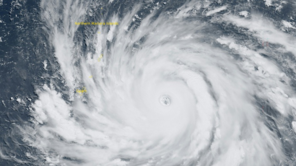
'Catastrophic' Super Typhoon Bavi hits US island of Rota / Photo: Handout - Colorado State University-CIRA (CSU/CIRA)/AFP
A "super typhoon" with equivalent force to a category-5 hurricane made landfall on the US island of Rota in the Pacific on Monday, the National Weather Service said, warning of "catastrophic damage and (a) life threatening situation".
"The western eyewall of Super Typhoon Bavi is currently moving over the island of Rota. The latest forecast intensity is at 180 mph (290 kph) as it passes over Rota," the NWS said. "Catastrophic winds exceeding 150 mph will continue across Rota during eyewall passage."
The weather system also brought extremely strong winds and lashing rain to other parts of the Northern Marianas and the nearby separate US territory of Guam, collectively home to around 210,000 people.
The island group around 6,000 miles west of the western mainland United States was already hit by another super typhoon in April, Sinlaku, that caused widespread devastation, ripping off roofs, knocking over trees and leaving tens of thousands without power.
In 2023 another massive typhoon, Mawar, the biggest in decades, did huge damage.
Before the NWS had said that a direct hit on Rota would make most of the island "uninhabitable for weeks, perhaps longer. Many non-concrete, non-reinforced homes will be destroyed, with total roof failure and wall collapse."
"Nearly all trees will be snapped or uprooted and power poles downed. Fallen trees and power poles will isolate residential areas. Power outages will last for weeks to possibly months," it said.
"By working together and taking the necessary precautions, we can help protect our families, neighbors and community. We pray for the safety of our people," Rota Mayor Aubry Hocog had said Sunday.
The small island, the southernmost of the Northern Marianas, is home to around 1,500 people.
- 'It hurts' -
Already on Sunday afternoon, there were few cars on the roads in Guam or the Northern Marianas with almost all stores closed, many of them with their windows boarded up.
Pinky Cubacub, 55, said she bought $500 worth of plywood at a lumber store for her eatery on Guam.
"I cannot afford to lose so many days. It hurts," she told AFP.
Call center employee Arabella Paulino, 48, said: "My girls were saying to me it's scary. But it will be okay."
"My house is concrete, so the worst that can happen is a window could blow in," she told AFP.
Japanese tourist Miku Sakurai, 25, was supposed to fly back to Tokyo with her friends but their flight was cancelled.
"We will stay in the hotel when the storm comes. I am scared," the office worker told AFP.
Around a dozen surfers, however, were making the most of the windy conditions at one beach in Guam's Talofofo Bay.
"There's quite a lot of debris in the water but it's a lot of fun," said one of them.
- El Nino -
The world's oceans experienced their hottest June on record and could set fresh highs in the months ahead, the European Union's Copernicus Marine Service said on Wednesday.
Warmer oceans help tropical storms to intensify and add more moisture, which can fall as heavy rain.
The World Meteorological Organization warned on Friday that El Nino, which typically occurs every two to seven years and lasts nine to 12 months, has already begun in the tropical Pacific and is likely to be strong.
The natural climate phenomenon warms surface temperatures in the central and eastern equatorial Pacific Ocean, bringing worldwide changes in winds, pressure and rainfall patterns.
M.Saito--JT